
How Thermal Drone Search and Rescue Works
- May 8
- 6 min read
A missing person call rarely arrives under ideal conditions. It comes after sunset, in broken terrain, in heavy tree cover, or after precious time has already been lost. That is where thermal drone search and rescue changes the pace of an operation by giving responders a faster way to scan ground, identify heat signatures, and direct personnel where they matter most.
For emergency response teams, law enforcement, volunteer SAR groups, and public agencies, speed is only part of the equation. The real value is better decision-making. A thermal-equipped drone can reduce blind searching, improve responder safety, and help teams cover more area with fewer unnecessary exposures to hazards on the ground.
Why thermal drone search and rescue matters
Traditional search methods still have a central role. Ground teams, K9 units, ATVs, helicopters, and community volunteers all bring strengths to the mission. But each asset has limits, especially at night or in areas where visibility drops to near zero.
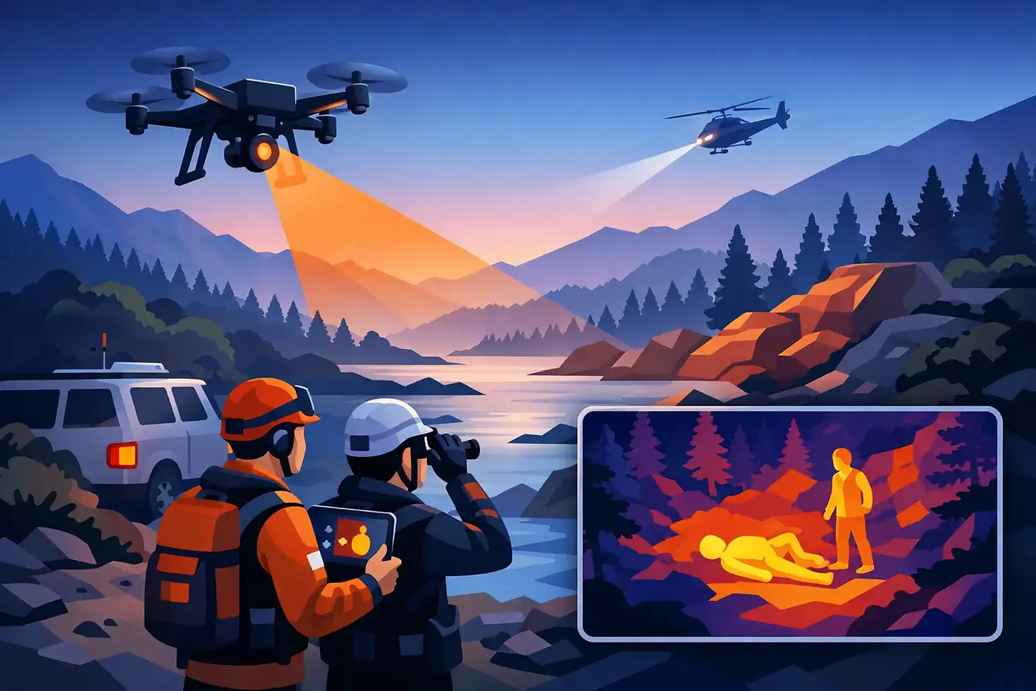
Thermal imaging helps close that gap. Instead of relying only on visible light, a thermal camera detects heat differences in the environment. A person lying in a field, moving through brush, or sheltering near a tree line may be hard to spot with the naked eye, but their heat signature can stand out from the surrounding terrain.
That does not mean thermal sees through everything. Dense canopy, hot pavement, sun-warmed rocks, and weather conditions can all affect what the pilot sees. The advantage is not magic vision. It is a disciplined, faster method for finding areas of interest and narrowing the search zone before teams commit more time and manpower.
What a thermal drone actually does in a search
In practical terms, a thermal drone extends the eyes of the incident team. Once launched, it can quickly scan fields, drainage areas, wooded edges, creek beds, rooftops, abandoned structures, and open land that would take much longer to search on foot.
The live feed gives command staff immediate situational awareness. If a heat source appears, the pilot can hold position, confirm movement patterns, compare thermal and visual views, and relay coordinates to personnel on the ground. That can turn a broad search into a targeted response in minutes.
This also changes how teams use their people. Instead of pushing searchers into every difficult area first, commanders can prioritize zones based on actual aerial intelligence. That matters when temperatures are extreme, terrain is unstable, or the operation stretches into multiple operational periods.
Thermal is strongest when time and visibility are working against you
Night searches are the obvious use case, but they are not the only one. Early morning operations, low-light woodland searches, flood zones, and rural property searches can all benefit from thermal imaging. The drone helps when visual contrast is poor and when covering ground quickly can influence the outcome.
In some cases, thermal can also help identify recent human activity. A warm vehicle, a body heat trace in an otherwise cool environment, or movement near structures can provide clues that guide next steps. Those clues still require trained interpretation, but they can be operationally significant.
The real advantage is safer, smarter deployment
Search and rescue is never just about finding someone. It is also about managing risk for the people conducting the search. Sending personnel into ravines, unstable buildings, flood-prone low areas, or remote fields without current aerial intelligence can slow the mission and create new problems.
A thermal drone gives teams a way to assess some of that risk before committing boots on the ground. It can identify obstacles, show whether a route is passable, and help locate people without immediately exposing responders to every hazard in the area. That is especially useful in winter exposure cases, wilderness searches, and incidents involving potential criminal activity.
For public-sector agencies and organized SAR teams, that operational picture supports better command decisions. For smaller jurisdictions with limited personnel, it can be even more important because every resource has to count.
What determines whether thermal imaging will be effective
Thermal technology is powerful, but performance depends on conditions and operator skill. The strongest results usually come when there is clear temperature separation between the subject and the background. A cool evening field can make a person stand out well. A heat-soaked urban surface after a long summer day can create more visual noise.
Vegetation is another factor. Light brush may still allow useful detection, especially with movement. Thick canopy can hide a person from any overhead sensor, thermal included. That is why experienced operators do not oversell what the equipment can do. They use it as part of a larger search strategy.
Altitude, flight path, sensor quality, and camera settings also matter. Flying too high may widen coverage but reduce detail. Flying too low may improve identification but slow the overall search. Good thermal drone search and rescue work depends on balancing coverage, resolution, battery management, and communication with incident command.
Training matters as much as the aircraft
A thermal camera only helps if the pilot and visual observer know how to interpret what they are seeing. Not every bright object is a person. Livestock, vehicles, HVAC systems, exposed rocks, and residual heat from structures can all create false positives.
That is where mission discipline separates a capable operator from someone who only owns advanced hardware. The operator has to understand scan patterns, environmental effects, handoff procedures, airspace considerations, and how to support ground teams without becoming a distraction. In mission-critical work, technology is only as reliable as the process behind it.
Where drones fit into a full SAR operation
Thermal drones work best as force multipliers, not replacements for established response methods. In many operations, they are most effective during the hasty search phase, the night phase, or when commanders need fast reconnaissance of specific sectors.
A drone may be used to clear large open areas first, check likely routes of travel, inspect retention ponds or creek corridors, or monitor team movement during difficult nighttime operations. It can also support perimeter checks and help document searched zones for better operational tracking.
For law enforcement and public safety agencies, thermal aerial support can be useful in missing person cases involving dementia, children, suspects who may be hiding, or individuals at risk due to weather exposure. For rural communities, farmland, and edge-of-town properties, drones often provide a faster first look than a full ground push.
In that environment, a service provider like Gods Eye Drone can offer meaningful support when agencies or organizations need certified flight capability, thermal imaging expertise, and an operator who understands that this is an operational mission, not a photo shoot.
What clients and agencies should look for
If your organization is considering thermal drone support, the first question should not be which drone is being used. It should be whether the operator is prepared for mission work. Licensing, insurance, airspace knowledge, and thermal payload quality all matter, but so do communication, reliability, and decision-making under pressure.
You want an operator who can integrate into a structured response, follow the chain of command, and provide clear, useful information instead of raw imagery without context. You also want someone who understands when thermal is likely to perform well and when conditions may limit results.
This is especially important for municipal agencies, sheriff's offices, fire departments, and volunteer SAR organizations that may call in support during high-stakes incidents. The right partner helps the team move faster without adding confusion.
The future of thermal drone search and rescue
The technology is improving quickly. Better sensors, stronger low-light cameras, longer flight times, AI-assisted object detection, and cleaner data workflows are making aerial search support more capable year by year. But the central mission stays the same: reduce time to detection and improve the odds of a safe outcome.
There will always be trade-offs. Dense woods can still block visibility. Weather can still ground aircraft. Some scenes will still require patient, methodical ground work. Yet when thermal drones are deployed correctly, they give responders something every search needs more of - actionable information.
When minutes matter and visibility is poor, that advantage is not theoretical. It can shape where teams go, how safely they move, and how quickly a search turns into a recovery or a rescue. The strongest operations are not the ones with the most equipment. They are the ones that use the right tools with discipline, clarity, and a clear purpose.


Comments